Summer/Fall 2023, Nine State Tour, 8.20.23 - 9.25.23, Part 6 of 9: The White Rim Trail
Anyone who has been to the Island In The Sky District of Canyonlands National Park and gazed out to the chaos of convoluted canyons below them, particularly from the White Rim Overlook, Green River Overlook or Grandview Point has surely been captivated by a thin line of dirt track that hugs the edge of the canyon rims. If you look down on Monument Basin or the Green River it is easy to see stretches of road running only a few feet from the very edge of sheer precipices. This track is known as the White Rim Trail. It is a one hundred mile Jeep road that mostly follows the rim of two rivers, namely the Colorado River along the eastern side and the Green River on the western side, stretching along the entire boundary of the Island In The Sky. It is extremely popular with the mountain biking community although Jeeps are also allowed to drive it. The road looks pretty flat from way up above but many sections are very rocky and there are several very challenging parts that give this road an intermediate rating for difficulty. Mountain bikers need several days to complete the ride and even Jeeps typically need at least two days to complete the full hundred mile trail.
Map of the White Rim Trail
There are twenty individual campsites arranged in ten different camping areas along the White Rim. All are considered official backcountry campsites and must be reserved in advance. There is no camping allowed outside of these designated backcountry sites. Reservations open for these sites four months prior to the dates you want to camp and they go very quickly.
As the White Rim Trail makes its way to the south it eventually comes to a point above where the Colorado and Green River meet. This point is known as the Confluence. High above the Confluence is a camping zone called White Crack. Unlike all the other camping areas, White Crack has only one individual site. I have heard that reserving a night at White Crack is more difficult than getting front row center to a Taylor Swift concert. Yet the reservation for the night of Wednesday, September 13th had the names Jon and Bridgit Newmark on it.
That morning, we woke up to a drizzly rain and I was a tad concerned about some of the steeper descents if the roads became slippery. I had asked about that at the ranger station the day before and been reassured that unless it really poured we should be fine. The ranger actually encouraged us to go for it, adding that she was more than a little jealous that we had a spot at White Crack. They said if by chance it really started raining hard to go back the way we planned to go in as that is much tamer than the other end.
We drove into Canyonlands and just beyond the entrance we turned onto the Shafer Trail. Before starting I aired down my tires to 25 psi for better traction and a smoother ride. Now before I go any further, I have to mention what an incredible wife I have. Bridgit and I drove on some insanely crazy stuff that most of the wives I know wouldn’t do for a million dollars. Not only did she handle it, she LOVED every minute of it, gripping the handles along the roughest parts and woo-hooing each time we climbed over a big rock or made it to the top of a particularly steep section. She was blown away by the capabilities of what our Jeep can do and truly relished the Jeeping experience. This was her first time to drop down the scary looking Shafer switchbacks. She would alternate between “Oh my God” and “Wow” the whole way down and when we got to the bottom of the switchbacks she exclaimed, “This is FUN”!!! She repeated that statement dozens of times throughout the course of the next two days.
At the bottom of the switchbacks we stayed to the right on the White Rim Trail. Our first stop was at the 6.6 mile mark. We pulled the Jeep over and took a short hike out to Gooseneck Overlook. This spot is has a tremendous view of a great bend in the Colorado River. The fact that it was still drizzling actually made the view much better than when Bob and I stopped there when the morning sun made it more difficult to see in that direction.
Gooseneck Overlook
Just a couple of miles further we came to a turnoff for Colorado River Overlook. This turnoff involved driving up a rocky shelf. Bridgit was unsure about whether we could drive up it but as we were crawling up the rock she was grinning ear to ear. This overlook wasn’t as good as Gooseneck but it was fun just to drive up to the end of the little side road to get there.
Now the road started to get a bit rockier and rougher so we slowed down to a crawl to minimize the jostling. Soon we came to another feature called Musselman Arch. So far we hadn’t seen anyone else. Musselman Arch looked more like a bridge than an arch to me since the top of it was flat but in technical terms, a bridge is formed by water flowing under it and an arch is formed by erosion. We walked over the arch which was wider than a sidewalk and took some photos. By now a tour van had arrived and I overheard the guide say that you are not supposed to walk on the arch. Oops. I hadn’t seen any signage regarding that and when I inquired he sort of grinned and said some tourist probably stole the sign as a souvenir. He didn’t seem too upset.
Some scofflaw on Musselman Arch
Looking down the length of Musselman Arch
Bridgit and I are always on high alert for wildlife on these trips. Rounding a corner I looked up and there on the hillside just next to the road was a family of four desert bighorn sheep. They seemed almost curious and we had time to get a few photos before they scampered off to higher ground.
Desert bighorn sheep
Desert bighorn sheep
Meanwhile, the rain had stopped and the sun was coming out again. In very high spirits we continued along the White Rim, with incredible vistas seemingly at every turn. It is impossible for me to explain what feelings these amazing desert panoramas conjure up for me. Maybe it has something to do with all the great westerns I watched on TV as a kid, but this is the west in its purest form. It has to be experienced to understand. Photographs just can’t possibly capture what it is like to be immersed in this environment.
Little Bridge Canyon
Airport Tower on left. Lathrop Canyon trail in foreground goes all the way down to the river. Bike/hike only.
One of the really cool things for me was to be driving through all the features I had previously only seen from high up on the mesas looking down. One in particular was Washer Woman Arch and Monster Tower. These two rock formations are in countless photos from up above. Mesa Arch at sunrise with the underside of the arch glowing in the rising sun with Washer Woman Arch and Monster Tower framed by the Arch is one of the most popular landscape images on Instagram. We had just been to Mesa Arch the previous day with Amy and Bob so now to be driving underneath it was a real treat.
Monster Tower and Washer Woman Arch on left
Monster Tower on the left, Washer Woman Arch on the right
Zoom of Mesa Arch from the White Rim Trail
Once we had passed by Monster Tower and Washer Woman Arch the road began to wind its way around the unbelievably incredible Monument Basin. Monument Basin is one of the most striking features along the entire length of the White Rim Trail. Up above on the mesas, a very short hike out to White Rim Overlook provides outstanding views straight down onto the basin as does the entire hike out to Grandview Point. To be driving right along the edge of this spectacular basin is an entirely different experience. At times the road was less than twenty feet from the edge of the cliffs that ringed Monument Basin. Looking into it, great pillars of rock rose up from the valley floor and beautiful layers of bright red rock created walls as if guarding the pillars. It was truly a sight to behold.
The road along Monument Basin
Yours truly at Monument Basin
Spectacular!
At this point we were driving right underneath White Rim Overlook and Grandview Point. I was so enamored with Monument Basin I think I forgot to look up to see if I could see anyone up there through the binoculars. Not much further beyond Monument Basin we came to the turnoff for White Crack. A 1.4 mile side road dropped us straight south to the very tip of Island In The Sky. It had taken us about six hours to drive roughly fifty miles.
Upon arriving at White Crack we ran into Craig and Mickey from southern California. We had been playing leapfrog with them along the route. They had a reservation for another campsite further down the main White Rim but had just driven down to check out what White Crack looked like. We would run into them several more times the following day. Once they left we could hardly believe our good fortune. White Crack might be the most stunning campsite we have ever spent the night at. The campsite itself is just an open area of slickrock with a few pinyon pines scattered about and a concrete outhouse which was nice to have. Although it wasn’t brutally hot, there was really no shade and since we had four hours until sunset we set up our camp chairs in the shadow of the Jeep and just relaxed in the warm Utah afternoon before putting up our tent. There was no dirt to speak of so the tent basically was set up on a flat area that was mostly rock. Once the tent was erected we were getting our bags and pads out of the Jeep when in no time flat a small breeze picked up the tent and flipped it over. We weren’t super close to the rim but we had visions of our tent sailing off the edge and floating down the Colorado River to Lake Powell. After that we put tent stakes flat through the eyelets, laid heavy rocks on the stakes to hold things down and that worked fine.
Our camp at White Crack
The campsite at White Crack is close enough to the confluence that a very short walk east or west of the site will bring you to the rim of the canyons. But the real treat is at the very point of the triangle. Around five in the afternoon we walked south over the slickrock for about ten minutes until we made it right to the southern-most tip of the Island In The Sky. Well almost the tip. I’m guessing White Crack is named for the large rock outcropping at the point. To reach it, one must first negotiate a six foot gap between the main bluff and the point and then an even larger gap to truly be as far south as you can get. Neither one of them looked like anything we wanted to attempt but no matter. The views laid out before us were simply indescribable, but I’ll try. As previously mentioned, The Island In The Sky is just one of three districts that make up Canyonlands National Park. Where we stood was at the tip of a giant triangle with the point facing down. Our position was higher in elevation than the scene before us so from where we were standing we were staring at a 270 degree view of the most wild terrain you ever could imagine. It is simply stunning. To the east the La Sal Mountains rose up to heights of close to thirteen thousand feet. Below the La Sals, the Needles District of Canyonlands spread out, with the namesake Needles rising up on the southern horizon. To the southwest, The Maze District was laid out in all its glory. I could see several of the places I had driven to back in 1990 on our epic Maze adventure, including the Land Of The Standing Rocks, Lizard Rock, the Plug, Chimney Rock, the Chocolate Drops and the Doll House where we had camped. Moving west, Elaterite Butte, Ecker Butte and Cleopatra’s Chair stood out on the horizon. Finally, right behind our camp to the north was Junction Butte and Grandview Point. It sounds cliche, but surveying this view took my breath away it was so beautiful.
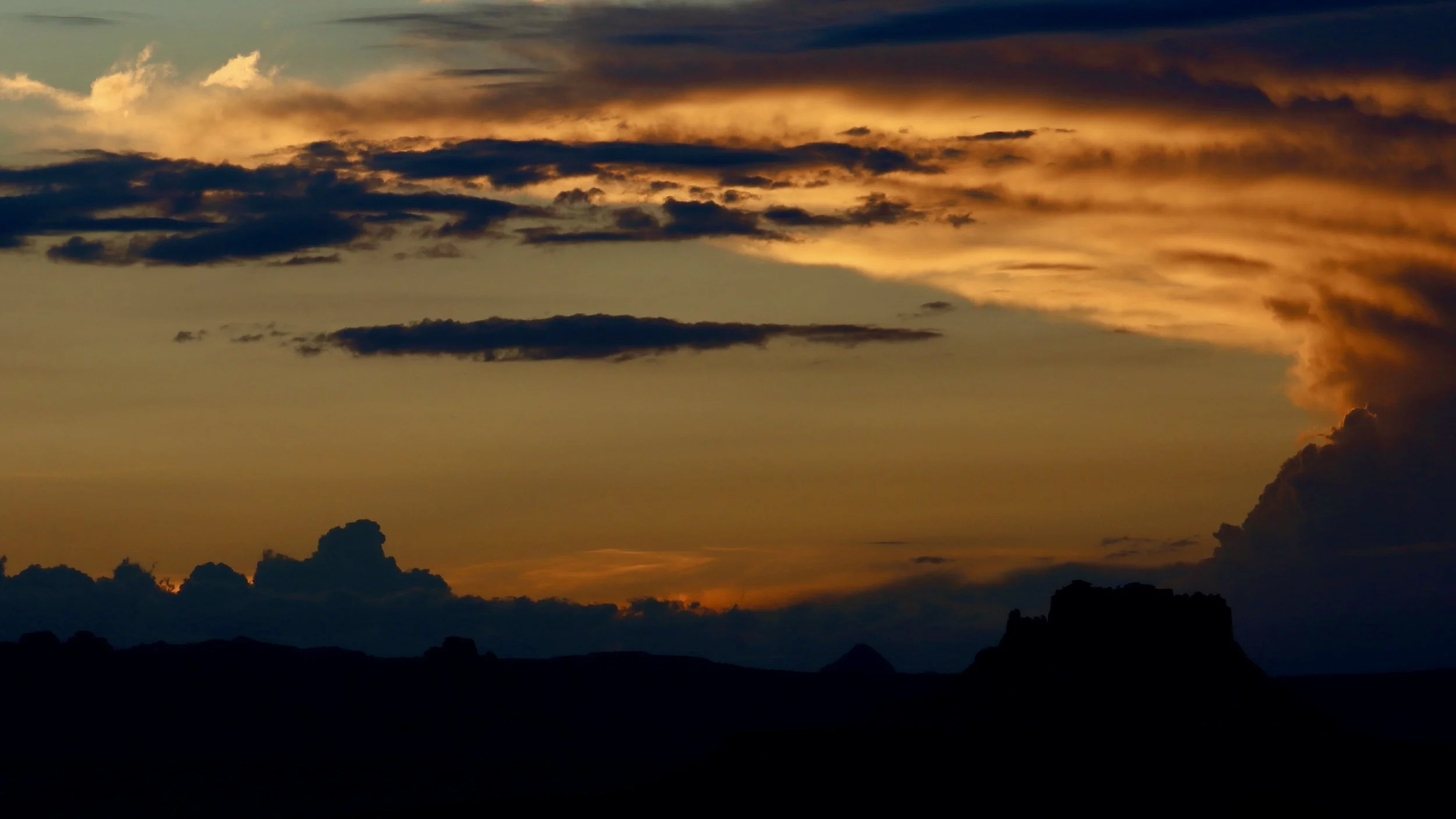
This was perhaps the one place I was looking forward to photographing the most, yet a fairly thick layer of storm clouds hovered in the west where the sun was slowly sinking. Patience can pay off and we were in no hurry so we spent a couple of hours out at the point and just like when we were at the Grand Canyon, as the sun sank lower and lower, the cloud layer slowly rose so that just before sunset the sun broke completely out of the clouds and bathed the entire scene before us in brilliant shades of glowing yellows, oranges and reds. It was everything I’d hoped for including a fantastic sunset when the sun finally dipped below the horizon.
The very tip of White Crack
I love these twisty trees!
Somewhere down there is the Colorado River
Looking southeast towards the Needles District
The Needles
Closeup of the Needles
The rim of Island In The Sky
Strange yucca stalks
Bluffs to the northeast
Last sunshine on White Crack
Fiery sunset
The end of the day
Sunset over Ecker Butte
It was so nice having this incredible campsite all to ourselves and we slept great. In the morning of course I was up before the sun and was treated to a really nice sunrise out at the point. Nice as it was, I think if I had to choose I would say the way the light at sunset hits the rocks is better than at sunrise, but they were both wonderful.
Sun about to rise behind the La Sal Mountains
Junction Butte behind our camp
The Maze District at sunrise
Sunrise glow on Elaterite Butte
The Doll House in the Maze District
It was hard to leave White Crack but we still had a long day ahead of us so we packed up camp and set out. Once we left White Crack we also left behind the Colorado River and now we were following the Green River, whose headwaters were back up in Wyoming in the Wind River Range where we had just been.
After passing several really nice side canyons, we came to Murphy’s Hogback. This was a very steep stretch of road that climbed up the side of the Hogback before topping out high above. I had been told and read about the hills on this side of the White Rim but I underestimated just how steep they really were. Climbing Murphy’s Hogback required 4WD low and a steady pace to keep momentum going. A bit of exposure off the driver’s side added to the fun. The Jeep handled it with no problem but it sure was steep!
Unnamed canyon heading towards the Green River
Murphy’s Hogback. It doesn’t look like much, but it was pretty steep!
At the top of Murphy’s Hogback was another camping zone which had some really nice sites with stellar views. Once again we ran into Craig and Mickey who had stayed there the previous night. They filmed us dropping off the other side of Murphy’s Hogback so we might get a video from them.
Continuing on we curved around past a really nice pillar called Candlestick Tower and stopped for lunch at the campsites near the tower. Now we were starting to get more views of the river. This section of the road can be seen very well from up on top of the mesas at Green River Overlook. From above it looks like the road skirts the very edge of the canyon rims and we discovered that’s because it does. We got some great views looking down an assortment of eroded side canyons before reaching the last big obstacle, a vile looking climb known as Hardscrabble Hill. We arrived at the base of the hill just after Craig and Mickey. They were driving a pickup with a topper on it and spent a bit of time assessing the hill before making a go of it. We waited from below in case they didn’t make it. I wish I had taken photos of this climb but I was too focused on the task before us to think about taking pictures. Craig and Mickey looked like they struggled but managed to make it up so we put ‘er down in low, took a deep breath and began the climb. This road was even steeper than Murphy’s Hogback It had a narrower track and more severe exposure, this time on Bridgit’s side of the Jeep. I knew if I stopped my momentum we might not make it so I crawled up the hill climbing over several rock shelves and keeping my foot on the gas. Halfway up an extremely tight switchback required a two point turn followed by an even steeper section. It was a white knuckler for sure but at the top we finally exhaled and let out a loud woo-hoo! I trusted the capabilities of my Jeep but definitely breathed a sigh of relief when we made it to the top.

Somewhere up there is Green River Overlook
Another cool side canyon
The road dropped quite steeply down the other side on a narrow, exposed track. At one point we met several vehicles coming up from the other direction. I pulled over as best I could but as they passed there was only inches between their tires and the abyss. It wasn’t the best place to be passing but I had nowhere to back up to.
As we dropped down further we began to get big views of the Green River and the feeling of completion began to sink in. We passed by another camp called Labyrinth where we met up one last time with Craig and Mickey. They agreed that Hardscrabble Hill was a lot tougher than they anticipated and like us, they breathed a big sigh of relief once they conquered it. They were staying a second night, this time at Labyrinth and had time to kill. I suggested they drive up a side canyon called Taylor Canyon. The road goes up about four and a half miles to a backcountry camp. There is a trail from there that loops around some really cool rock pillars called Moses and Zeus. Craig and. Mickey - if by chance you read this and went up there, send me an email and some pics telling me about it.
Coming off Hardscrabble Hill to the Green River
From Labyrinth we dropped down to the level of the Green River and followed a sandy track through beautiful scenery for several miles before reaching our exit junction. Taking a right, we climbed up and out of the river on the Mineral Bottom Road. It was similar to the Shafer Switchbacks although not quite as scary looking. Once we had climbed out and were back up on top of the mesas it was a just a long drive on a dirt road to get back to the highway just a few miles from where we had began the journey. I aired up the tires back to their normal psi and we started back towards Moab. It felt strange to be on pavement. Once again, our timing was impeccable. Other than an hour of drizzle the first day, we had beautiful weather the rest of the trip. But as we drove back, the skies opened up and we got a downpour. Along the road between Navajo Rocks and US 191, dozens of great waterfalls of brown muddy water poured off the cliffs all around us. It is easy to see how people get caught in flash floods in the desert. Conditions can change in an instant.
So the White Rim trip was pretty much as good as it gets. We both thought it was one of the more amazing experiences we’ve ever had. A special thanks goes out to our friends Mike and Sandy. They have biked and driven the White Rim dozens of times and provided a wealth of information during our planning phase. And the best part was that we still had two more days in the area before our next leg of the Nine State Tour!